🗺️ Plate I: Map of the Ancient Monarchies (Interactive Map Viewer)
Enlarged Ancient Monarchies Map
💡 Thao tác: Lăn con chuột để Phóng to / Thu nhỏ • Bấm giữ chuột trái để Kéo (Pan) di chuyển bản đồ • Nhấn phím Esc để Đóng.
Student Name:
Date:
Class / Grade:
Ancient World History • Earliest Civilizations

THE MOST ANCIENT NATIONS

Extending from the Earliest Ages to the Foundation of the Persian Empire by Cyrus the Great • Part I
Primary Source Reading Passage (Sections 1 – 2)

1. THE exact date of the Creation and Fall of Man can-not be fixed with any degree of certainty, neither can the interval of time between the Creation and the Deluge be ascertained. The estimates of different chronologists as to these facts vary so widely that they seem worthy of no credence whatever. The difficulty of assigning the exact time of those events does not, however, at all diminish the evidence of their actual occurrence.

2. After the dispersion of mankind at Bā'bel, it is supposed that the descendants of Shem, the eldest of Noah's sons, went to the east and populated Asia; those of Ham, with few exceptions, passed into Africa; and those of Jā'phet journeyed to the west and occupied different parts of Europe. The oldest monarchies, of which history gives us any account, are those of BABYLONIA and ASSYRIA in Asia, and those of EGYPT and ETHIOPIA in Africa.

Section 1

Lesson Review & Historical Comprehension

1.
Can the exact date of the creation and fall of man be fixed?
Address what the text states regarding the interval of time between the Creation and the Deluge, and explain whether chronological uncertainty disproves their actual occurrence.
2.
What events immediately followed the dispersion of mankind? Whither did the sons of Noah migrate?
Identify the central site of dispersion (Bā'bel) and trace the migration destinations of the three branches: Shem, Ham, and Jā'phet.
3.
Which are the oldest monarchies recorded in world history?
Classify the four foundational kingdoms into their respective continental domains (Asia vs. Africa).
Student Name:
Date:
Class / Grade:
Ancient World History • Historical Geography

Historical Geography & Map Inquiry

Map Analysis: The Cradles of Ancient Civilizations (See Map, Page 12) • Part II
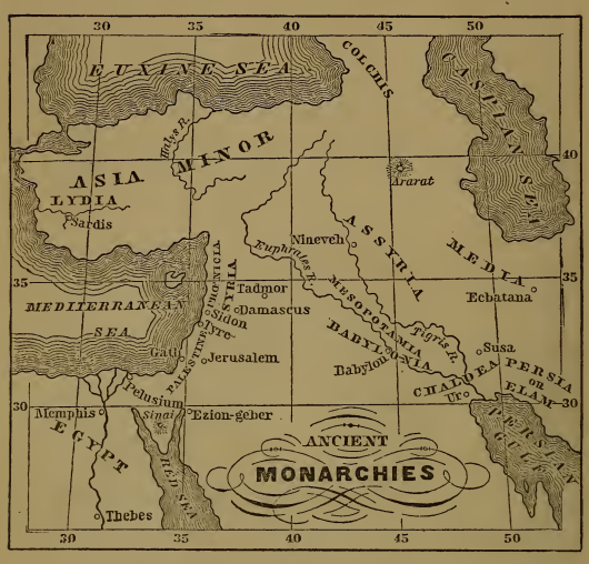
Map of Ancient Monarchies
🔍 Bấm để phóng to
Plate I: Map of the Ancient Monarchies (Page 12)
Geographical Features on Map:
  • Seas & Gulfs: Euxine (Black) Sea, Caspian Sea, Mediterranean Sea, Red Sea, Persian Gulf.
  • Great Rivers: Euphrates R., Tigris R., Halys R. (Asia Minor), Nile R. (Egypt).
  • Kingdoms & Empires: Babylonia, Assyria, Chaldea, Media, Persia/Elam, Lydia, Egypt.
  • Principal Cities: Babylon, Nineveh, Ur, Susa, Ecbatana, Memphis, Thebes, Sardis, Damascus, Tyre, Sidon, Jerusalem.
  • Maritime Ports: Pelusium (Nile Delta), Ezion-geber (Head of Red Sea).
  • Sacred Mountains: Mount Ararat (North), Mount Sinai (South).
Section 2

Map Questions & Territorial Geography

4.
The Mesopotamian River Valley & Persian Gulf:
What rivers unite and flow into the Persian Gulf? What region is situated between them? Where were Babylonia, Assyria, Chaldea, and Persia (Elam) located?
5.
Principal Cities, Empires of Asia & The Euxine Sea:
What city was in Babylonia? In Chaldea? In Assyria? In Media? Where was Susa? What river tributary flows into the Euxine (Black) Sea? What monarchy in Asia Minor, and its capital? What region east of the Euxine Sea?
6.
The Levant, Nile Valley & Sacred Topography:
What regions lie east of the Mediterranean Sea and their principal cities? What two great cities on the Nile River? What port at its eastern mouth? What port at the head of the Red Sea, and what celebrated mountain near it?
[TEACHER ANSWER KEY & SCORING RUBRIC] LESSON 2 • TOTAL SCORE: 20 POINTS

Master Answer Key: The Most Ancient Nations

Comprehensive Model Responses & Grading Criteria for Questions 1 – 6
1. Exact Date of Creation, Fall & Deluge [3 Points]
• Dating Impossibility: The exact date of the Creation and Fall of Man cannot be fixed with any certainty, nor can the exact interval between Creation and the Deluge (Great Flood) be ascertained.
• Chronologists' Variance: Estimates of early chronologists vary so widely that they seem worthy of no credence.
• Historical Occurrence: The chronological difficulty does not at all diminish the evidence of their actual occurrence.
2. The Dispersion at Babel & Migration of Noah's Sons [4 Points]
• Dispersion Site: Mankind dispersed following the confusion of tongues at Bā'bel.
• Descendants of Shem: Migrated to the east and populated Asia (Semitic nations).
• Descendants of Ham: Passed into Africa (origin of Hamitic/African peoples).
• Descendants of Jā'phet: Journeyed to the west and occupied different parts of Europe (Indo-European branches).
3. The Four Oldest Monarchies of the World [3 Points]
• Monarchies in Asia: Babylonia (lower Mesopotamian plain) and Assyria (upper Tigris valley).
• Monarchies in Africa: Egypt (lower/upper Nile valley) and Ethiopia (Nubian/upper Nile domain).
4. Mesopotamian Hydrography & Regional Territories [4 Points]
• Rivers: The Euphrates and the Tigris unite and flow into the Persian Gulf.
• Region Between: Mesopotamia (literally "the land between the rivers").
• Territorial Positions: Assyria lay in the northern river valley; Babylonia and Chaldea occupied the southern fertile plain near the gulf; Persia or Elam lay eastward beyond the rivers; Media lay northeast of Babylonia.
5. Ancient Capital Cities, Susa, Asia Minor & Euxine Sea [3 Points]
• Principal Cities: Babylon (Babylonia), Ur (Chaldea), Nineveh (Assyria), Ecbatana (Media).
• Location of Susa: Capital of Persia or Elam (Susiana).
• Asia Minor Monarchy & River: Lydia (capital: Sardis); the Halys River flows into the Euxine (Black) Sea.
• Region East of Euxine Sea: Colchis (fabled land of the Golden Fleece).
6. The Levant, Nile Valley, Red Sea Ports & Sacred Mountains [3 Points]
• Regions East of Mediterranean: Syria (cities: Tadmor / Palmyra, Damascus), Phoenicia (ports: Sidon, Tyre), Palestine (cities: Gath, Jerusalem).
• Nile River Cities: Memphis (north) and Thebes (south).
• Ports & Mountains: Port at eastern Nile mouth is Pelusium; port at head of Red Sea is Ezion-geber; celebrated mountain near it is Mount Sinai (and Mount Ararat in the north).
[TEACHER LECTURE & EXPLANATORY GUIDE] LESSON 2 • INSTRUCTIONAL METHODOLOGY

Teacher's Lesson Lecture & Historiographical Notes

Hướng Dẫn Giảng Dạy Sư Phạm & Phân Tích Chuyên Sâu Cho Giáo Viên Đứng Lớp
1. Niên Đại Học Cổ Sơ: Sự Bất Định vs Tính Chân Thực Lịch Sử (Section 1)
• Trọng tâm bài giảng: Làm rõ cho học sinh mệnh đề triết học quan trọng: Việc không thể ấn định ngày tháng chính xác không hề phủ nhận sự tồn tại có thật của sự kiện. Các niên đại cổ trước thời văn tự lưu trữ thường có độ lệch lớn giữa bản dịch Septuagint (Hy Lạp) và Masoretic (Do Thái).
• Định hướng sư phạm: Khuyến khích học sinh phân biệt giữa "tính tuyệt đối của niên đại toán học" và "sự thực lịch sử về nguồn gốc con người và các biến cố hồng thủy đã để lại dấu ấn trong huyền thoại mọi nền văn minh".
2. Biến cố Babel & Bản Đồ Phân Bố Nhân Loại (Table of Nations - Section 2)
• Nguồn gốc các nhánh ngôn ngữ & dân tộc:
  + Nhánh Shem (Châu Á): Khởi nguồn ngữ tộc Semitic (người Hebrew, Ả Rập, Assyria, Babylon, Phoenicia).
  + Nhánh Ham (Châu Phi): Khởi nguồn nền văn minh Ai Cập (Khem), Ethiopia (Cush), và các tộc người ven Địa Trung Hải.
  + Nhánh Japhet (Châu Âu): Tiến về phương Tây, đặt nền móng cho ngữ hệ Ấn-Âu (Indo-European: Hy Lạp, La Mã, Celt, German).
• Ý nghĩa lịch sử của Tháp Babel: Đại diện cho bước chuyển từ một cộng đồng nguyên thủy duy nhất sang các xã hội đa ngôn ngữ, thúc đẩy sự phân tán địa lý và hình thành bản sắc văn hóa.
3. Khai Thác Bản Đồ Cổ: Địa Lý Lưu Vực Sông & 4 Vương Triều Cổ Nhất (Page 2 Map)
• Quy luật phù sa (Alluvial Soil): Chỉ rõ trên bản đồ hai con sông Tigris và Euphrates uốn lượn đổ về Vịnh Ba Tư, tạo nên vùng đất Lưỡng Hà (Mesopotamia) màu mỡ giữa sa mạc khô hạn. Tương tự, sông Nile chảy ngược từ nam lên bắc nuôi sống Memphis và Thebes.
• Sự phân bố 4 vương triều:
  + Babylonia & Chaldea (Nam Lưỡng Hà): Đô thị Babylon và Ur, trung tâm nông nghiệp và thiên văn học.
  + Assyria (Bắc Lưỡng Hà): Đô thị Nineveh, cường quốc quân sự kiên cố trên vùng đồi cao.
  + Ai Cập & Ethiopia: Vương quốc sông Nile kéo dài từ Địa Trung Hải xuống Nubia.
4. Các Điểm Nút Giao Thương & Địa Danh Thiêng (Levant, Sinai, Ararat)
• Dải duyên hải Levant (Phoenicia & Syria): Tyre, Sidon là các hải cảng thương thuyền trứ danh; Damascus và Tadmor (Palmyra) là trạm trung chuyển ốc đảo giữa sa mạc nối Lưỡng Hà ra biển.
• Cửa ngõ chiến lược: Susa án ngữ con đường sang cao nguyên Ba Tư; Pelusium là chiếc chìa khóa phong tỏa đường bộ vào châu thổ Ai Cập; Ezion-geber mở lối hải trình ra Ấn Độ Dương.
• Núi thiêng: Núi Ararat (nơi con tàu Noah đậu lại) ở vùng cao nguyên Armenia phía bắc; Núi Sinai ở mũi bán đảo nối Ai Cập và biển Đỏ.
💡 Gợi Ý Câu Hỏi Vấn Đáp Socrates Dựa Trên Bản Đồ & Định Hướng Trả Lời (Discussion Prompts):
1. "Observing the flow of the Tigris and Euphrates on the map, why did the ancient empires of Babylonia and Assyria not expand toward the southwest (Arabian Desert), but rather along the river valleys toward Syria and the Mediterranean (the Fertile Crescent)?"
(Quan sát dòng chảy của sông Tigris và Euphrates trên bản đồ, tại sao các đế chế Babylon và Assyria không mở rộng về phía tây nam sa mạc Ả Rập mà bành trướng theo thung lũng sông về phía Syria và Địa Trung Hải?)
➜ Định hướng trả lời cho giáo viên:
• Hậu cần & nguồn nước: Sa mạc Ả Rập khô hạn khốc liệt, hoàn toàn không có nước và đồng cỏ cho kỵ binh, khiến việc hành quân viễn chinh và đóng quân là bất khả thi.
• Hành lang Trăng Lưỡi Liềm Màu Mỡ (Fertile Crescent): Bành trướng dọc theo thung lũng Euphrates lên phía bắc (Syria) rồi vòng xuống Địa Trung Hải giúp quân đội luôn bám sát nguồn nước ngọt, khai thác lương thảo dồi dào từ đồng bằng phù sa và làm chủ các tuyến giao thương huyết mạch Á – Phi – Âu.
2. "Why did city-states like Tyre and Sidon become the most prosperous maritime commercial centers of the ancient world despite having very narrow territorial land?"
(Tại sao các thành bang như Tyre và Sidon lại trở thành trung tâm thương mại đường biển thịnh vượng nhất thế giới cổ đại dù lãnh thổ trên đất liền rất hẹp?)
➜ Định hướng trả lời cho giáo viên:
• Thế đất "Lưng tựa núi, mặt hướng biển": Dải duyên hải Levant bị dãy núi Lebanon chặn sau lưng khiến đất nông nghiệp chật hẹp, buộc người Phoenicia phải hướng ra biển để mưu sinh và phát triển.
• Tài nguyên quý & độc quyền mậu dịch: Sở hữu rừng gỗ tuyết tùng (Cedar of Lebanon) tuyệt hảo để đóng tàu viễn dương lớn; độc quyền kỹ nghệ nhuộm vải tím hoàng gia (Tyrian Purple) đắt hơn vàng. Vị trí địa lý biến Tyre và Sidon thành trạm trung chuyển độc quyền nối hàng hóa nội địa phương Đông (Lưỡng Hà, Ba Tư) với toàn cõi Địa Trung Hải (Ai Cập, Hy Lạp, Carthage).